
TROPICAL Depression Mirasol (International name: Mitag), which exited the Philippine area of responsibility (PAR) on Thursday morning, intensified into a tropical storm bringing heavy rains to Luzon, while Tropical Depression Nando is expected to develop into a typhoon, which could trigger wind signals in the coming days, the state weather bureau said on Thursday.
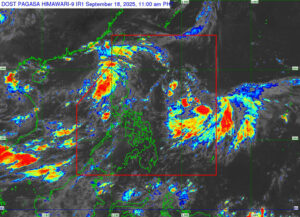
“The trough of the tropical storm is still affecting extreme Northern Luzon as well as the Ilocos Region,” Leanne Marie Loreto, weather specialist of the Philippine Atmospheric, Geophysical, and Astronomical Services Administration (PAGASA), said in Filipino during a 5 p.m. press briefing. Mirasol left PAR at 6 a.m.
Mirasol, with sustained winds of 65 kilometers per hour (kph) and gusts of up to 80 kph, was last located 465 km West of Calayan, Cagayan, moving westward at 15 kph, Ms. Loreto said.
She added that it is also slightly enhancing the southwest monsoon, bringing overcast skies and scattered rain showers in the evening over Zambales, Bataan, Pampanga, Bulacan, and Metro Manila.
The weather system is likewise affecting Calabarzon, MIMAROPA region, western Visayas, Negros Island Region, and Zamboanga Peninsula, which may trigger flashfloods and landslides.
PAGASA has already lifted all tropical cyclone wind signals (TCWS) for Tropical Depression Mirasol, as of the latest forecast period.
Over 1,000 individuals, or 233 families, were affected by Tropical Depression Mirasol, primarily in Cagayan Valley, central Luzon, and Bicol region, according to the National Disaster Risk Reduction and Management Council’s (NDRRMC) 8 a.m. situational report on Thursday.
There were no casualties or injuries reported.
Meanwhile, Tropical Depression Nando maintained its strength, with sustained winds of 55 kph and gusts of up to 70 kph, according to PAGASA’s 5 p.m. bulletin.
“As it moves, it may further intensify into a typhoon as early as Saturday… We are also not ruling out the possibility that it could reach the super typhoon category,” Ms. Loreta said.
Nando was located 1,260 km East of Central Luzon and moving northwestward at a speed of 15 kph.
As of the forecast period, Nando is less likely to directly affect the country within the next 48 hours. However, PAGASA said TCWS No. 1 may be raised on Saturday in affected areas, with the possibility of TCWS No. 5 if Nando intensifies into a super typhoon.
PAGASA advised residents in high-risk areas to follow evacuation orders and other instructions from local officials. — Edg Adrian A. Eva