
PRESIDENT Ferdinand R. Marcos, Jr. has ordered all government agencies to implement proactive measures as the state weather bureau expects tropical depression Crising to intensify into a severe tropical storm by Saturday.
In a press briefing on Thursday, Presidential Communications Undersecretary and Palace Press Officer Clarissa A. Castro said concerned agencies are now on high alert as they conduct pre-disaster risk assessments at the President’s directive.
The National Disaster Risk Reduction and Management Council (NDRRMC) on Thursday afternoon declared a red alert status, requiring duty officers from the Armed Forces of the Philippines, Bureau of Fire Protection, Philippine Coast Guard, Philippine National Police to render duty at its operations center in Quezon City.
Technical staff from other agencies such as the Department of Science and Technology-Philippine Atmospheric Geophysical and Astronomical Service Administration (PAGASA), Department of the Interior and Local Government, Department of Social Welfare and Development, Department of Agriculture, among others, are also called to gather at the operations center.
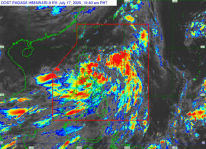
Crising was spotted at 335 kilometers northeast of Virac in Catanduanes or 545 km east of Baler, Aurora, as of 4 p.m., PAGASA said in a 5 p.m. report.
It was moving west northwestward at 30 km per hour, packing maximum sustained winds of up to 55 km/h, gustiness of up to 70 km/h, and central pressure of 1000 hPa. PAGASA said strong winds extend outwards up to 500 km from the center.
Crising may make landfall over mainland Cagayan by Friday, the weather bureau noted.
Moreover, it is expected to intensify into a tropical storm on Thursday evening or early Friday morning and further intensify into a severe tropical storm by Saturday morning or afternoon.
“Further intensification over the Philippine Sea and the possibility of reaching Severe Tropical Storm before landfall is not ruled out,” it said.
The NDRRMC said in a situation report on Thursday there were already three landslides and 19 flooded areas due to Crising and the southwest monsoon in central Visayas.
PAGASA has raised wind Signal No. 1 in several Luzon areas such as Batanes; Cagayan including Babuyan Islands; Isabela; Quirino; the northern portion of Nueva Vizcaya (Kasibu, Quezon, Bagabag, Diadi,
Bayombong, Solano, Ambaguio, Villaverde, Dupax del Norte, Bambang, Kayapa), the northern portion of Aurora (Dilasag, Casiguran, Dinalungan, Dipaculao, Baler), Abra, Apayao, Kalinga, Mountain Province, Ifugao, and the northern portion of Benguet (Bakun, Mankayan, Buguias, Kibungan, Kabayan, Bokod, Atok, Kapangan).
Also under Signal No. 1 were Ilocos Norte, Ilocos Sur, the northern portion of La Union (Bangar, Sudipen, Luna, Balaoan, Santol, San Gabriel, Bacnotan), Polillo Islands, Camarines Norte, the northern portion of Camarines Sur (Caramoan, Garchitorena, Lagonoy, San Jose, Presentacion, Tinambac, Siruma, Goa), and Catanduanes.
FLOOD CONTROLThe Department of Environment and Natural Resources, meanwhile, urged local government units (LGUs) to integrate comprehensive flood risk reduction programs into their design and solid waste management plans.
LGUs should pursue ecosystem restoration by implementing green infrastructure and restoring natural water systems to absorb excess rainwater, it said in a statement.
They should incorporate modern drainage solutions that can handle increased rainfall volumes and ensure that waste management systems prevent blockages in drainage systems, it added.
The Philippines, which is highly vulnerable to climate change, may see 11 to 19 tropical cyclones from July to December, about two to three of which this month, PAGASA said in June.
An average of 19 to 20 storms develop inside the Philippine area of responsibility each year, with about 8 or 9 making landfall.
In January, the Department of Agriculture said calamities including tropical cyclones, the El Niño weather pattern, pests, and volcanic activities, among others, resulted in P57.78 billion in agricultural damage in 2024.
The Philippine Rice Research Institute (PhilRice) on Thursday urged rice farmers in Central Luzon and the Bicol Region to step up field surveillance as wet‑season weather is expected to fuel pest and disease outbreaks.
Citing the Bureau of Plant Industry, it flags brown planthopper, bacterial leaf blight, rice blast, rice stemborer, and rodents as the top threats for the July‑to‑September quarter.
“Cloudy, rainy days with temperatures of 25‑30 °C are ideal for brown planthopper outbreaks. We expect heavier infestations and more cases of hopperburn,” PhilRice crop‑protection specialist Leonardo V. Marquez said.
He urged growers to plant pest‑resistant varieties, synchronize sowing dates, keep paddies weed‑free, alternate wetting and drying, and apply fertilizer judiciously to curb pest buildup.
Stemborer pressure could also rise, because plentiful rainfall encourages back‑to‑back cropping and short fallow periods that let the insect persist, he added.
Rodent damage is projected to peak in Mindanao’s Bangsamoro Autonomous Region in Muslim Mindanao, where continuous rains spur weed growth and reproduction, and to be lowest in the typically drier Ilocos region.
“If the cost of control outweighs the expected gain, it may be wiser to wait and prepare for the next season,” PhilRice said. — Kyle Aristophere T. Atienza with Chloe Mari A. Hufana